
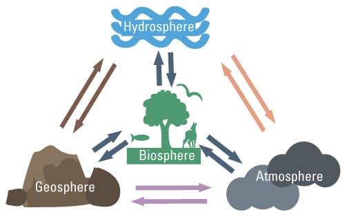
Earth's Systems
¿De qué trata este proyecto?
- Edad de los estudiantes
- 16-18 años
- Duración del proyecto
- 5 semanas
- Mes de inicio
- Noviembre 2026
Objetivos de aprendizaje
Habilidades a desarrollar


Actividades del proyecto
Meet the partner class and map our Earth spheres
Students introduce their locality and themselves to the partner class, then brainstorm what the atmosphere, hydrosphere, geosphere, and biosphere look like around them.
Map the four spheres of our local area
In small groups, students survey and map the atmosphere, hydrosphere, geosphere, and biosphere in their neighbourhood, using photos, local data, and observations. They then draw the links they see between the spheres.
Research how the spheres interact in our region
Students investigate specific local interactions, such as how rain affects soil or how plants shape air quality, and record evidence for each connection. They prepare questions to compare with the partner class.
Compare maps with the partner class in a live video call
Both classes share their maps during a live video call and compare how each sees the connections between the spheres. Students discuss similarities and differences across regions and take notes on what surprises them.
Analyse intercultural differences in an online forum
Students use a shared forum to analyse why their perspectives differ, referring to local culture, climate, and land use. They run a short survey on how each community views these connections and summarise the findings.
Present our revised Earth-system maps
Students present their revised maps and the key insights they gained from the exchange to both classes. They end with a reflection on how intercultural perspectives changed their understanding of the spheres.